


Share:
A research project on urban solar potential mapping by Chen-Yuan Hsieh, Tzu-Ting Lin, and Yu-Chen Yeh, students from the Department of Urban Planning and Spatial Information at Feng Chia University, won first place in the university division of the 8th National Land Spatial Information GIS Competition on July 1. The project also drew the attention of the Ministry of the Interior's National Land Surveying and Mapping Center (NLSC) and Academia Sinica. Through a partnership between government, academia, and industry, the winning project has been expanded into the Building Rooftop Solar PV Potential 3D Search Service, which the public can use for free. The system currently covers Taichung City, and it was scheduled to expand to all six of Taiwan's special municipalities by the end of August 2026.
Under the Standards for the Installation of Solar Photovoltaic Power Generation Equipment on Buildings, new buildings, extensions, and renovations with a floor area of 1,000 square meters or more are generally required to install 1 kilowatt (kW) of solar PV capacity for every 20 square meters. To help the public, the construction sector, and the solar industry understand what each building can support, the NLSC invited the award-winning team to scale up its research. The Center for GIS at Academia Sinica's Research Center for Humanities and Social Sciences, Feng Chia's Department of Urban Planning and Spatial Information, and Zang-Shi Technology Co., Ltd. then worked together to develop the system and put the research into practical use.
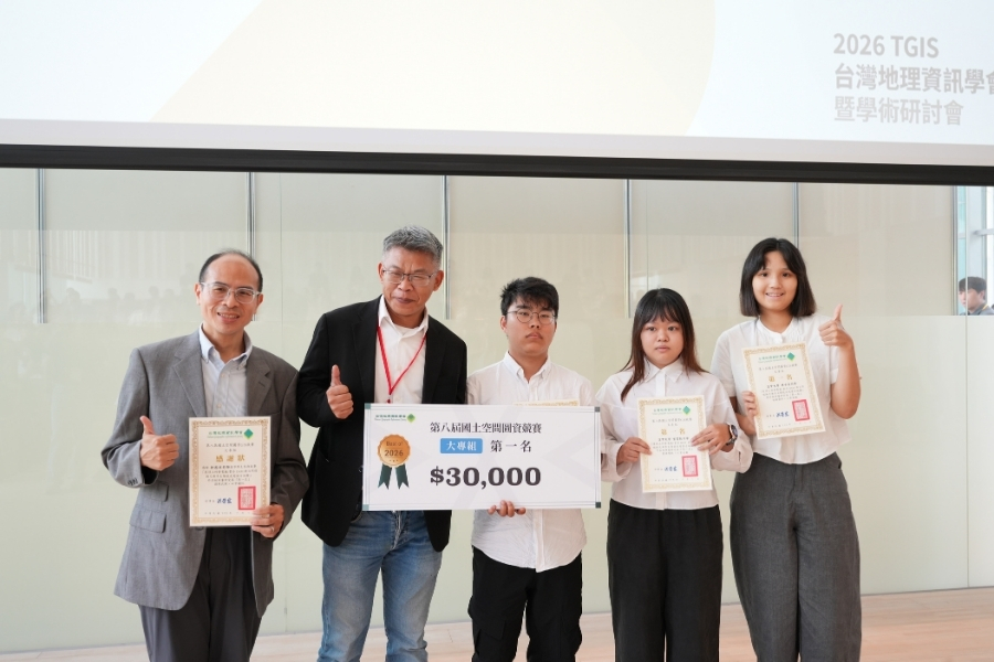
Associate Professor Yi-Shiang Shiu (first from left) of Feng Chia University's Department of Urban Planning and Spatial Information advised students Chen-Yuan Hsieh, Tzu-Ting Lin, and Yu-Chen Yeh, who won first place in the university division of the 8th National Land Spatial Information GIS Competition. Director-General Chia-Cheng Lin (second from left) of the Ministry of the Interior's Department of Land Administration presented the award.
The service combines the Ministry of the Interior's multi-dimensional spatial data, terrain, shading simulations from surrounding buildings, and national land-use data. It also accounts for practical factors such as solar panel conversion efficiency, the system Performance Ratio (PR), how much of each rooftop can actually be used, and the published feed-in tariff rates. With these inputs, it estimates each building's usable installation area, expected installed capacity, power generation potential, and financial return.
Associate Research Specialist Hsiung-Ming Liao of Academia Sinica, who helped bring the partnership together, explained: "Users go to Academia Sinica's 3D Spatio-Temporal Information Integration Platform, search for the 'Building Solar PV Potential' function, and enter a street address. The system then locates the building automatically." Using 3D building models, users can view the area available for power generation and the estimated revenue. A "draping" function shows the generation potential of different parts of the roof.
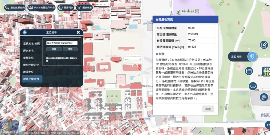
Academia Sinica, Feng Chia University, and the Ministry of the Interior have launched the Building Rooftop Solar PV Potential 3D Search Service. Users can enter a street address to check a building's solar PV installation conditions and power generation potential.
Associate Professor Yi-Shiang Shiu of the Department of Urban Planning and Spatial Information said, "This work started as an undergraduate research project. It was tested in a competition organized by the Taiwan Geographic Information Society, and in the end, government, academic institutions, and industry worked together to turn it into a digital public service everyone can use." He added that the result shows how students' ideas can meet real national policy and social needs, and it reflects Feng Chia's cross-disciplinary strength in spatial information and urban planning.
The project began as a study of industrial zones in Taichung and became a public service through a clear division of work. The NLSC supplied national spatial data. The Department of Urban Planning and Spatial Information built on the student team's work to create models for rooftop sunlight and PV potential. Academia Sinica and Zang-Shi Technology developed the 3D GIS search interface. By pooling their resources, the three sectors turned a campus idea into a practical tool that supports Taiwan's net-zero policy.
Share:
Related News